Date
R7 May 2020 through December 2020
Parent Page: R7 PNF Plug and Play PnP and R7 5G Service Modeling
Previous Meetings: PNF PLUG and PLAY in R6 Frankfurt
Goals
- Discuss PNFD/SDC AID/A&AI Schema Mapping - Action Items and Geolocation
- 5G Service Modeling
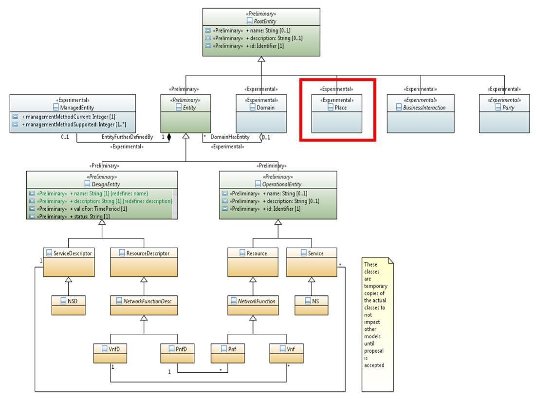
MAJOR TOPIC #1a - PLACE OBJECT (CLOSED)
| TOPIC | DISCUSSION |
|---|---|
| DEVELOPMENT OF LOCATION MODEL for PLACE OBJECT in ONPA PLATFORM INFORMATION MODEL | Development of Location Model for Place object in ONAP Platform Information Model. Place has been introduced as Experimental Wiki page for root: Root (Root Model object)
ACTION: Information Model &PLACE Object proposal Start with "as built" model / Bob Papa & SALVATORE RICCI ACTION: R7 need & application? VNF will likely need the address/location info/complex before PNF. (1) Containerization (2) multi-cloud 3rd party clouds & (3) attributes missing or extended A&AI schema update (4) support globalization. / VNF verizon ETSI alignment R7 Use Case "Onboard ETSI SOL004 compliant VNF packages" ACTION: Generic Information Template page for Generic Information Element Definition for Geolocation Model: Generic Information Element Definition for Geolocation Model PROPOSED LOCATION MODEL: |
| INTEGRATION OF COMPLEX OBJECT & PLACE OBJECT | How do we associate in the model and execute in A&AI code - the inter-dependencies between the Place object and complex Refactoring code, A&AI data model, may need to refactor code. These part of place object implemented as part of the complex object. The complex object is in the addendum at the bottom of this Wiki ACTION: How would this tie into the complex object or link/associate with the complex object. CONTACT: Jimmy Forsyth ACTION: (OPEN) (Oct 3) - Jimmy (A&AI PTL) said that Complex Object is entwined in the code; hard to redact it; smarter to evolve. Tie place object into the complex object; maybe complex could be subobject of place. Jimmy also mentioned that the Place & complex could be linked together. Maybe complex would be a subobject to place if there is overlap in fields & concepts. output of Graphgraph need UML model ACTION: Complex object reverse engineering - Mapping of Place & A&AI Complex Object / Do an analysis on the Complex object / Reverse engineer of Complex / logical model vs grounding in current implementation → evolution / who will consume changes & use cases - downstream system / Standards → Needs Use Cases → Information Model → Objects & Data Model / Subject Modeling S/C. Globalization of location information / simple things we can do wo/ breaking the complex object e.g. changing behavior applied to multiple countries are we missing attributes evolving location info for other U/C needs. |
| NEXT STEPS (R8) |
|
MAJOR TOPIC #1b - GEOLOCATION BASE INFO (Standards) / (Closed)
| TOPIC | DISCUSSION | ||||||||||
|---|---|---|---|---|---|---|---|---|---|---|---|
| GEO-LOCATION STANDARDS & REFERENCES (Summary) | STEP 1: Standards Inputs for place IM Object
| ||||||||||
RFC6225 GEOLOCATION FIELDS | Geolocation fields from RFC6225. (CLOSED) – see table below ACTION: (DONE) Fill in tie-in fields to standards elements
| ||||||||||
COMMON LOCATION MODEL / GB922 | Standard TM Forum GB922 - Location Modeling Discussion (Email) TMF SID classes for Urban Property Address and Urban Property Sub-Address as per: https://www.tmforum.org/resources/suite/gb922-information-framework-models-r18-5/ | ||||||||||
| COMPLEX OBJECT w/ PLACE-LOCATION OBJECT | COMPLEX OBJECT: How-To: Register a VIM/Cloud Instance to ONAP click on "CREATE A COMPLEX OBJECT" AAI REST API Documentation - Frankfurt (swagger for complex object) / Info Model - Data model Map between.
| ||||||||||
| ETSI SOL 001 | ETSI SOL001 - work with ETSI to incorporate it into ETSI SOL 001. Incorporate Geolocation element into ETSI SOL 001 standards. ACTION: (DONE) Contacted Thinh N. (Nokia); Thinh RESPONDED to bring it up at the Modeling Call. Ben → Contact Thinh ACTION: (DONE) Proposal in ETSI. Geoloc harmonization standards would go back to ETSI SOL001. Incorporate into Standards. |
MAJOR TOPIC #2 - PNFD MAPPING & SOL001
| Item | Notes |
|---|---|
MULTI-LANGUAGE SUPPORT | LANGUAGE – Check on representation of location for Non-western Languages & scripts. Civil address specify in the data. How would A&AI represent addresses but expressed in different language. Store the address with way to designate language type. Relevant only if SP deals with more than one language at a time. DISPLAY - If SDC and VID do not display multi-lingual support, do we assume that the Latin alphabet would be displayed for non-Latin characters? STORAGE - How would other languages be stored in the fields which will store location/address/place information.
|
| ALIGN SOL001 & A&AI | 12 elements from the civic_address_element that do not map “nicely”: division, block, street group, additional loc info, residence name, unit, floor, room, postal name, PO box, additional Code, seat/cubicle/work station. We have decide to use "MAP" data structure in CA Place object fields. ACTION: (DONE) done with analysis & development of the PLACE & Complex object. Result use "MAP" structure in Place object fields |
| Setting the Geolocation information | ACTION: Adding information to A&AI, A&AI software development to support the PLACE model. A&AI Schema. ACTION: PNF use place object and VNFs continue to use Complex. SO in the PNF BB. (1) PNF registration VES event could send Geolocation (2) Operator of ONAP sets the information with a SO BB W/F. Who is updating, creating, maintaining and consuming it? Anyone using the complex object need to update. Set by external API. Receive & validate info a PNF (audit) |
PNF PLUG and PLAY / PNFreg VES ETSI Mapping SOL004 | During PNF PnP PNFRegistration VES event will send information about the PNF Eventually FILLS civic address & geolocation . (1) VES PNFregistration VES events need to be updated. SOL004 PNFD Vendor Package. (2) decide which parameters we want to have the VES event report. ACTION: (Eventually incorporate new civic address & geolocation info into the PNFregistration VES event) Software updates to handle Place object information during PNF registration |
TOPIC #3
| TOPIC | DISCUSSION |
|---|---|
| PNFD MAPPING | PNFD and ending up in an instance data (A&AI Model mapping). From PNFD (onboarded) loaded into SDC AID to A&AI Improvement of ingestion onto SDC AID PNF ETSI NFV SOL001 - descriptor_id, function_description, provider, version, descriptor_invariant_id, name, geographical_location_info, virtual_link SDC - invariantUUID, uui, customizationUUID, version, type, name, description, resourceVendor, resourceVendorRelease, resourceVendorModelNumber, category, subcategory, nf_function, nf_role, nf_type, software_versions ACTION: Go to SDC and/or CDS. Identify Use Case. Will specification for geolocation in SOL001. Geolocation in PNFD not per site. Inventory information. For vendor may not be so useful as sites instances are tied to locations not so much descriptors; for service provider probably country or region may be useful. Onboarding in ETSI. SDC → Vendor PNFD → SDC Model PNF instance modeling tied to A&AI reverse engineering. will go into the resource IM meetings. |
TOPIC #4 5G Service Modeling (3rd Thursday of Each Month)
| TOPIC | DISCUSSION |
|---|---|
| 5G Service Model Use Case | The 5G service model use case in R6: 5G RAN SERVICE MODELING & DEFINITION in R6 Frankfurt 5G Service Model U/C in R7: R7 5G Service Modeling Highlights of 5G Service Model U/C
NEXT STEP: Modeling discuss with Modeling S/C. What do we need to store; information model for C&PS. path to follow to get to info needed which guides API development & schema formation. Storing information relates to Netconf yang model ; common constructs topo endpoint that you would hang w/ more detailed implementation specific resource information; extend it for any resource; common constructs. ONF. R7 mature a model to evolve. Introduce modeling requirement |
LOGISTICS
| TOPIC | DISCUSSION |
|---|---|
| TIMETABLE (WHAT RELEASE TO INTRODUCE) | In R7 OOF SON PCI Use case uses the concept of Geolocation as it relate to Cell Objects, which is a "first application" for the Geolocation model development. |
| MEETING INFO | Meeting on the FIRST Thursday of Each Month ONAP Meeting 4 is inviting you to a scheduled Zoom meeting. Meeting ID: 112 318 171 |
| R7 Model Release Planning | ONAP R7 Modeling High Level Requirements Modeling Activity & Use Case Relevance. See Category 2 (table 2) for Geolocation development |
FILES & PRESENTATIONS
| Desc | File |
|---|---|
| new PNF PLACE Object (June 2020) | |
PNF Place Object (July 2020) |
ATTENDEES
| DATE | Attendees |
|---|---|
| |
| |
| Benjamin Cheung Tony Finnerty |
| Benjamin Cheung Jacqueline Beaulac Timo Perala Martial Ngueko |
| |
| |
RECORDING
| Date | Zoom Recording | Audio File |
|---|---|---|
| ||
| ||
| ||
| ||
| ||
| ||